Table of Content
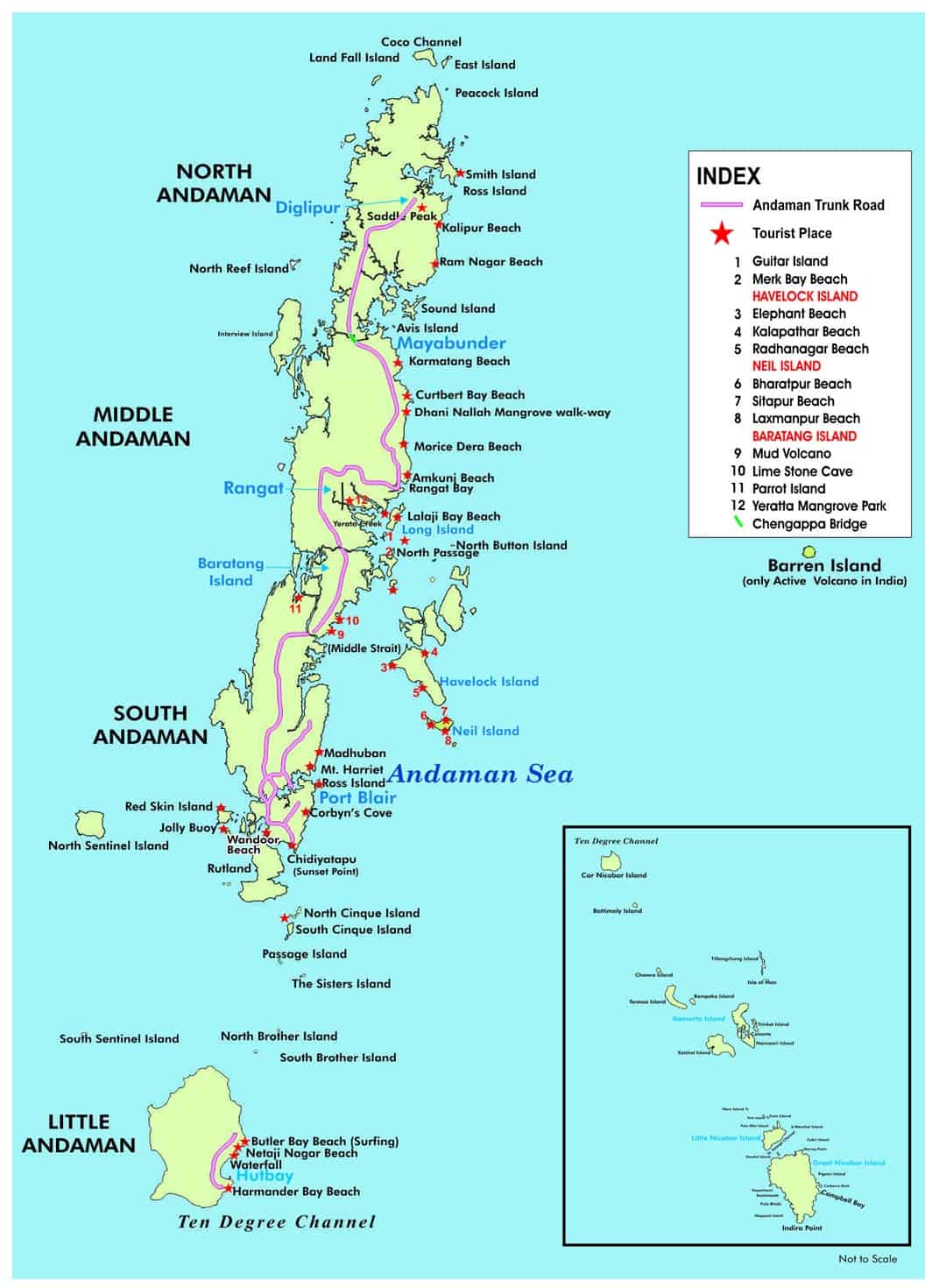
Map of Andaman Islands


Andaman Tourist Map
An island is where life starts. Every island is a reflection of how life evolves. Made from bed of volcanic rocks islands like those in Andaman harbour million years of geology, history and marine life which the tribes discuss in their tradition. That’s why you see bigger and larger species in islands than in the mainland. It’s an ecological hotspot. This is what draws people and academics all alike. Visiting Andaman is like visiting a subdued version of the Galapagos Islands.
Knowing this, I ventured on my island journey last December with my parents. While they were on their touristic pursuit I was there to discover.Back then the tourist map of Andaman and Nicobar Islands wasn’t something I had in mind as I thought I would get it on the internet and travel. But it proved otherwise.
Getting To the Island
An Arthur Conan Doyle fan and Sherlock addict I had thought of the tribes of the land many a time. Afterall who could forget Tonga from ‘The Sign of Four’. The popular story was based on the real life story of Jack Andaman – a little Andamanese boy who was captured by the British and brought to Calcutta. But he perished soon.
Much of Andaman remains mired in such stories set amidst a fragile ecological reality and I was to explore both. With this intention I landed in Port Blair on a bright sunny touristy December Sunday for a 7 day Andaman trip on a budget.
Read More: Best Time to Visit Port Blair
But getting to Andaman is one thing and manoeuvring through it is a different thing altogether. There are various information available over the internet which paints a different picture from reality. So, getting an Andaman and Nicobar Islands map and knowing the landscape is the first step of deciding on a tour.
Different kinds of Andaman Islands maps are available on the internet and in popular places. However none of them is concrete. First you must take a look at an ecological Andaman offline map to know the ecological aspect of it. The Andaman Trunk Road runs straight all over North, South Andaman, Middle Andaman and Baratang. You would be traveling along this road to visit places on this island and then take a 2–3 hour ferry from Port Blair to Havelock and to other popular islands like Neil and more.
This Andaman offline map given in author Pankaj Sekhsaria’s book “The Last Wave” shows that. Most of the popular tourist destinations are displayed on the tourist maps of Andaman and Nicobar Islands, available in popular tourist spots. But it’s not enough to move with this information alone.
Using Andamans Maps
An interesting Andaman and Nicobar Islands Map brochure caught my mother’s attention on our first day in Andaman. She caught hold of a map from Go2Andaman which had well articulated information regarding
- Popular Routes and Trails
- Public Transport Points,
- Spots for Adventure Sports
- Activities
- Restaurants
- Hotels
- ATM and Money Exchange Centres
- Cab Numbers, Airline Helplines
- Helpline Numbers and Police Emergency Contacts and Even Areas to look for Valuable Shopping
This Andaman offline map even traced out some less traveled destinations.


Customer Happiness
Secure Payments
No Hidden Costs
Fast Confirmations
Stay updated with all the excitement that Andamans has to offer

If you have a flair for writing, write for us and get featured.
Get lost or never. You decide. Download our handy tour guides to plan your trip.